-

From the fall of Atlantis...
-
To a forgotten past...
-

Clues in ancient maps...
-
And accidental revelations...
-

The post war truth revealed...
Academically they are quite right, but how on Earth could an 18th Century
cartographer possibly know that millions of years ago the hidden continent had
an inland sea-way running through its middle? The answer is simple, he could not, for the technology that revealed this has
only been developed this century and man simply did not exist in any
intellectual form when this knowledge was last known. And yet it appears that Bauche did know. (To see these map images in more detail click
here.). Perhaps, however, there is another solution that fits the
facts of these maps a little more comfortably and credibly. History records that as early as the 6th Century
BCE, Pythagoras was proposing that the Earth was round, and other academics,
Parmenides (450BCE), Aristotle and Eratosthenes (276-194 BCE) agreed (32). By 150 CE the
Egyptian geographer, Ptolemy, had concluded that the world was symmetrical and
must therefore have a southern continent - Terra Australis
Incognita, however he also believed that this southern continent was cut off
from the known world by a 'Torrid Zone' of fire and fearful monsters (33).
The concept then,
of an undiscovered southern continent, has been held for over two millennia. Ptolemy's teachings, however, became lost in the Middle Ages, but
were preserved by the Arabs.
They reappeared in Europe from the 10th
Century onwards as the Moors invaded Spain. Then in 1410,
Ptolemy's works were translated into Latin and French and became accessible to a
wider audience, stimulating curiosity to discover the unknown continent. Later that century the fear of the Torrid Zone was finally
overcome as Bartholomew Diaz reached the Cape of Good Hope in 1488 and was
followed a decade later by Vasco de Gamma who went round it to reach India.
The
significance of these voyages being that it became known that Africa was merely
an extension of the known world, the Torrid Zone was fictitious and the southern
continent, if it existed, lay elsewhere and further south and was accessible.
Then, in 1501 a Florentine seaman, Amerigo Vespucci, set off to explore the
South American coastline. Exactly what areas Vespucci explored are unknown, but
it appears that he charted the area, for when Magellan journeyed there in
September 1519 he seemed to have knowledge of the coastline, noting:
"This strait was a circular place surrounded by mountains, and to most of those
in the ships it seemed that there was no way out from it to enter the said
Pacific Sea.
But the captain-general said that there was another strait which led out, saying
that he knew it well and had seen it in a marine chart of the King of Portugal,
which a great pilot and sailor named Martin of Bohemia had made (34)."
Magellan
also reported seeing land to the south, land that became known as Tierra del
Fuego. From information taken from Magellan's voyage, a map was later
constructed in Antwerp in 1570. The map showed Terra Australis as extending
south from Tierra del Fuego off the tip of South America. (It was not
until 1577 when Drake charted the area that this mistake was rectified.) The
important point to note here is that early maps simply placed the southern
continent, which had been 'known' about for centuries, somewhere outside known
and charted areas.
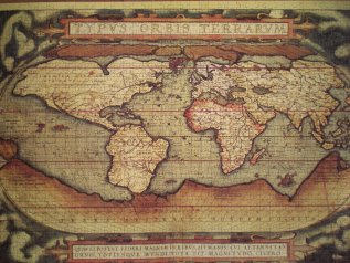
As a result of this, earlier maps appear to be more confident about the southern
continent than slightly later maps which were based on actual data rather than
accepted concepts. For example the 1620 Dutch map below starts to show the
outline of the southern coast of Australia and some tentative lines around
Antarctica, from reports from ships that strayed south. Now as far as the Piri Reis map is concerned it appears much more
likely that its sources lay in slightly earlier cartography undertaken by peers
such as Vespucci who had been in the area a mere 13 years previously than some
'lost civilisation' who supposedly lived there - without trace - thousands of
years before any civilisation is known to have existed and in conditions that
would have made living there an impossibility at that time. It also appears suspicious that both the Piri Reis map and the map from
Magellan's voyage both crush 'Antarctica' against Southern America, suggesting
they are contemporaneous in origin rather than divided by thousands of years.
As far as the Oronteus Fineaus, Bauche and other ancient maps
are concerned, they all date from no earlier than the beginning of the
16th Century - a time when we know voyages were taking place in the
area and maps were tentatively being drawn, even if they were inaccurate. Given that we also know that Antarctica had been in sub-zero temperatures for
thousands of years, has had no plant life for millions of years, is bathed in
darkness most of the year round and the so called ancient map 'evidence' of life
there does stand up to any real scrutiny, it is not hard to conclude that
Antarctica was not the location of the lost people.
So how can the discovery of ferns, dinosaurs and other mammal
life on a once warm Antarctica be explained? Here, at least Hapgood et al were
treading on safer ground, for whilst Earth Crust Displacement may have
been proved to be a fallacy, the theory of Continental Drift has is
origins firmly roots in science and fact. This theory suggests that the Earth's crust is split into a
number of 'plates' that support the continents. These plates are moved around
the ocean spreading (the addition of new crustal rock along mid-oceanic ridges)
and by convection currents in the rocks of the Earth's mantle, beneath the
crust. This theory helps explain how fold and block mountains, volcanoes and
earthquakes occur.
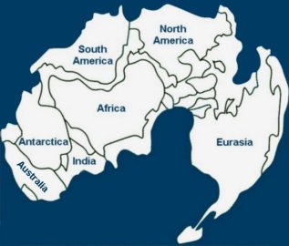
Antarctica then, was not always hiding in the sunless frozen
wastelands of the planet, but many millions ago was located further north where
it enjoyed a more temperate climate. When the Lystrosaurus roamed the
continent, the Earth resembled the top illustration and by the time the
Cryolophosaurus ellioti was making its mark on the planet, Antarctica had
broken away to form its own continent. Over millions of years
the continents continued to drift away from each other, with India ploughing
across the oceans to later collide with Asia and force up the Himalayan
Mountains. Slowly the continent drifted into what is now called the Antarctic
Circle, making conditions impossible for land mammals to survive.
So with Antarctica ruled out, it appears that the search for
the location of any lost peoples has been exhausted. Yet despite this, there
remain those intriguing puzzles that simply cannot be explained by conventional
history. If no-one on Earth can account for them, then perhaps we should be
looking elsewhere.


|

|
Explore forgotton clues scattered throughout history that are suggestive
of an alternative history.

Join the world-wide search for evidence
of a lost civilisation that predates
known history.

Has Earth already been contacted by other civilisations either in the distant past or in recent centuries?

A discussion of the emergence of advanced technologies and the bizarre invasion of Antarctica after WWII.

A discussion of sightings of UFOs in the sky above Earth and within the solar system, including Moon anomalies.

Evidence the Earth has been visited by extraterrestrials and how the public had been subject to disinformation.

Violations is now available to purchase in
paperback or Kindle versions complete
with exclusive additional content!
