Ancient Antarctica Maps
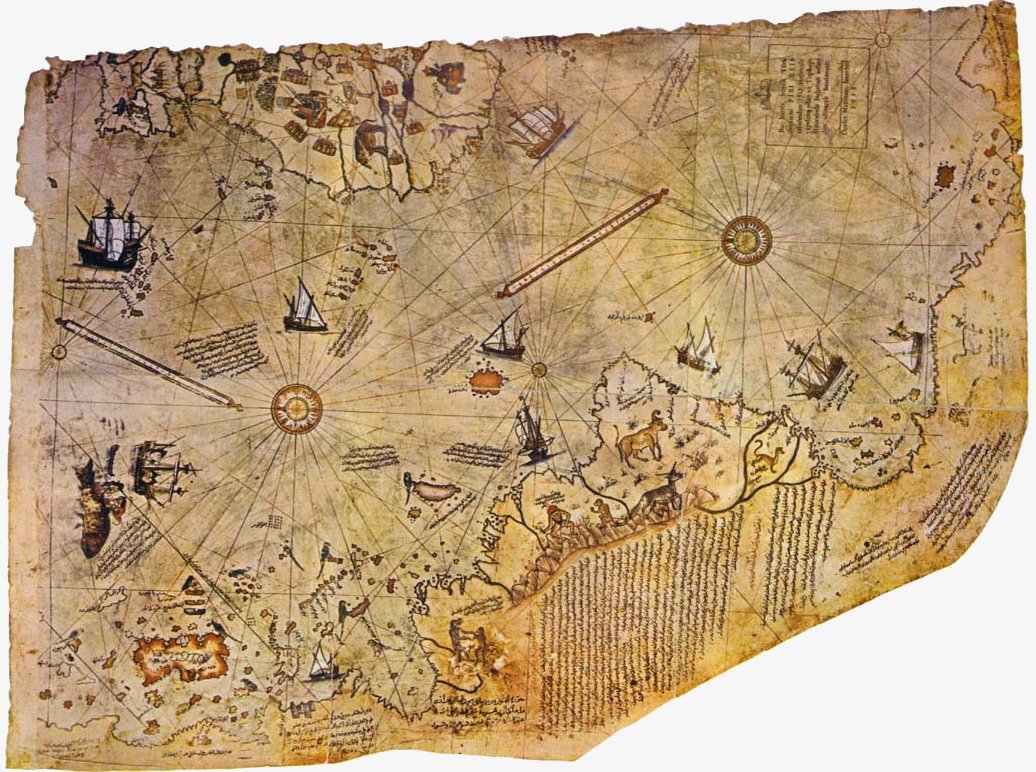
This map, as discussed in Chapter 3 Weird History has strong credentials, however, there are clearly serious flaws in it suggesting that it should be treated with caution when cited as evidence of the existence of an early and lost civilisation. One such flaw is that of the island shown at 0 degrees latitude and just east of longitude 47 degrees W on the parchment. Hapgood refers to this island as "one of the major mysteries of the Piri Reis map" (18). He continues, "the details of the island are convincing. Some reproductions of the coloured facsimile (but unfortunately not all of them) suggest by a deeper shade around the coasts that there were coastal highlands or mountains surrounding a great central plain. The harbours and islands off the coast are inviting. They are carefully drawn. There seems to have been an effort to achieve accuracy (19)." Hapgood notes that the island has now disappeared into the ocean, "submerged to a depth of a mile and a half." (20)
 Hapgood was convinced that if he could only prove that this island had existed, then this would silence any doubters once and for all; for it was the degree of detail in the Piri Reis map that so convinced him of its accuracy (once realigned to modern scales). He therefore decided to approach the US Government for help and permission to search for underwater cities in the region of the St Peter and St Paul Rocks. By October 1963 Hapgood had presented a convincing enough argument to secure an interview with President Kennedy to discuss the matter further. However, as history records, fate intervened. In actual fact, even if the interview had gone ahead, it would not have changed the fact that the island shown on the map is not presently submerged beneath the Atlantic nor did it ever exist.
We know this now because the US Navy has recently released satellite data gathered by the US Navy's Geostat spacecraft between the 31st March and 30th October 1986 that was used to prepare the first detailed topographic map of the entire ocean floor (21). The Piri Reis 'missing' island should therefore have appeared on this map of the seabed, however the Geostat map shows no evidence of any such island nor any submerged mountains. Indeed the only topographic forms that can be seen in the area where the island 'should be' are numerous transform faults, ridges and trough topography that characterises normal oceanic crust. If Piri Reis could 'invent' an entire island of considerable dimensions, then surely he could also make-up the supposed outline of Antarctica?
Obviously the answer is yes, however it should be remembered that Piri Reis readily admitted that he had merely complied his world map from twenty or more smaller maps, and these in turn were probably compiled from even smaller and older maps. Consequently, some areas of the overall map will be accurate whilst others inaccurate and without doubt the original source maps would have been the most accurate of all for these are the maps that would have actually been used by those who drew them. In essence, just because part of the map is erroneous, does not make it all so. Indeed, the map itself was a working tool used by mariners and others. It would hardly have enjoyed this status had it been so riddled with errors that it would have been safer to voyage blind.
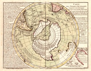
Yet it is the outline of the Antarctic area we are interested, rather than that of South America, Africa or Spain. Clearly if there were other ancient maps of the area then this would lend credence to the idea that it really had been mapped before becoming entombed in ice. Hapgood himself realised this and searched for further supporting evidence. His search was to lead him to the Reference Room of the Library of Congress, Washington DC, America. Hapgood recalls; "I found ... many fascinating things I had not expected to find, and a number of charts showing the southern continent. Then one day, I turned a page and sat transfixed. As my eyes fell upon the Southern Hemisphere of a world map drawn by Oronteus Fineaus in 1531, I had the instant conviction that I had found here a truly authentic map of the real Antarctica. The general shape of the continent was startlingly like the outline of the continent on our modern maps. The position of the South Pole, nearly in the centre of the continent, seemed about right."

|
|

|